

Districts in Singapore
Reading Time: 5 minutesThe establishment of Singapore’s districts and postal districts can be attributed to historical, geographical, and administrative factors. The development of these districts was influenced by urban planning initiatives and the need for efficient postal services. They provide a structured framework for the organization of amenities, services, and postal services, contributing to the overall efficiency and functionality of the city-state.
Singapore’s Districts: The districts in Singapore were initially established during the colonial era when the British ruled the island. The city was divided into different settlements and districts, each serving specific administrative purposes. The Central Area emerged as the commercial and administrative hub, while other regions developed as primarily residential or had distinct economic functions.
Over time, urban planning and development shaped the districts in Singapore. The Urban Redevelopment Authority (URA), Singapore’s national urban planning agency, played a pivotal role in defining the districts and guiding their growth. The URA formulated long-term plans and guidelines to ensure sustainable and efficient land use, with a focus on creating self-sufficient towns and vibrant economic centres.
The districts were designed to provide a balanced distribution of amenities, services, and economic activities across the city-state. This approach aimed to reduce congestion in the city centre, enhance accessibility, and improve the quality of life for residents in different regions. Each district has its unique character, with a mix of residential, commercial, and recreational areas.
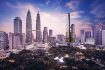
- Central Area: The Central Area is the heart of Singapore’s business and financial activities. It encompasses the Downtown Core, where you’ll find iconic landmarks like Marina Bay Sands, Raffles Place, and the Civic District with historical sites such as the National Museum and Fort Canning Park.
- North Region: The North Region of Singapore is primarily residential and spans across districts like Woodlands, Yishun, and Sembawang. It is known for housing several recreational and leisure destinations, including the Singapore Zoo, Night Safari, and the scenic Mandai area.
- North-East Region: Located towards the northeastern part of Singapore, the North-East Region comprises districts such as Hougang, Serangoon, and Punggol. This region is characterized by a mix of public and private housing, shopping malls, and popular food enclaves like Chomp Chomp Food Centre.
- East Region: The East Region features districts like Bedok, Tampines, and Pasir Ris. It is known for its vibrant cultural diversity, excellent dining options, and recreational areas such as East Coast Park, a popular spot for outdoor activities and seaside dining.
- West Region: The West Region encompasses areas like Jurong, Bukit Batok, and Clementi. It is a hub for industrial and commercial activities, with Jurong Industrial Estate being one of Singapore’s largest industrial estates. The region also offers nature parks, including Bird Paradise and the Chinese and Japanese Gardens.
- South Region: The South Region covers districts like Queenstown, Bukit Merah, and Sentosa. It is a mix of residential, commercial, and recreational spaces. The iconic Sentosa Island is a major attraction, featuring theme parks, beaches, and resorts, while areas like HarbourFront and VivoCity offer extensive shopping and entertainment options.
- North-West Region: The North-West Region includes districts such as Bukit Panjang, Choa Chu Kang, and Woodlands. It is mainly residential, with a mix of public and private housing. This region also offers green spaces like Bukit Batok Nature Park and Bukit Timah Nature Reserve for nature lovers.
- South-East Region: The South-East Region comprises districts like Marine Parade, Geylang, and Bedok. It is renowned for its vibrant local culture, bustling markets, and vibrant food scene. The East Coast area in this region is a popular spot for recreational activities, including cycling and watersports.

Singapore’s Postal Districts: The concept of postal districts in Singapore was introduced to facilitate efficient mail delivery and postal services. The development of postal districts was influenced by the growth of the city and the need to organize mail operations effectively.
In 1979, the Singapore Postal Services Department implemented the Postal District Code System. Under this system, Singapore was divided into multiple postal districts, each identified by a unique code. The districts were initially delineated based on geographical boundaries and localities to streamline the sorting and delivery of mail.
The postal districts were designed to ensure that mail was efficiently routed and delivered to various parts of the city-state. Each district had its central post office or sorting centre, serving as the main facility for mail processing and distribution within that district.
The postal districts aligned closely with the existing administrative and geographic divisions in Singapore, such as planning areas and residential towns. Over time, the boundaries of the postal districts have been adjusted to accommodate changes in urban development and to optimize mail delivery routes.
The postal codes within each district provide a more precise identification for specific locations within a district, enabling accurate and efficient mail sorting. The first two digits of the postal code generally correspond to the postal district, while the subsequent digits further specify the specific sub-zones or sectors within that district.
| District | Postal Sector (1st 2 digits of 6-digit postal codes) | General Location |
|---|---|---|
| District 01 | 01 | Marina Bay, MBS, Gdn By The Bay |
| District 01 | 02 | Marina East, Marina Bay Golf Course |
| District 01 | 03 | Serangoon Central, Serangoon Garden |
| District 01 | 04 | Raffles Place, Boat Quay. Circular Road, Battery Road, Fullerton |
| District 01 | 05 | People’s Park, China Town, Outram |
| District 01 | 06 | Robinson, Cecil Street, Shenton Way, Telok Ayer, Maxwell |
| District 02 | 07 | Tanjong Pagar, Tras Street |
| District 02 | 08 | Cantonment Road, Keppel |
| District 04 | 09 | Telok Blangah, Harbourfront, Vivo City, Mount Faber Road, Sentosa |
| District 04 | 10 | Telok Balngah, Depot Road |
| District 05 | 11 | Alexandra, Labrador, South Buona Vista, Pasir Panjang |
| District 05 | 12 | Clementi, West Coast |
| District 05 | 13 | Buona Vista, North Buona Vista, Dover |
| District 03 | 14 | Alexandra, Queenstown, Queensway, Margaret Drive, Bukit Merah |
| District 03 | 15 | Alexandra, Hoy Fatt, Rumah Tinggi, Lengkok Bahru, Leng Kee, Redhill, Jalan Bukit Merah, Henderson |
| District 03 | 16 | Tiong Bahru, Bukit Ho Swee, Lower Delta, Jalan Bukit Merah, Havelock Road, Kim Tian |
| District 06 | 17 | High Street, Clarke Quay, River Valley Road |
| District 07 | 18 | Tan Quee Lan, Rochor Road, Queen Street, Bugis Junction, Sim Lim |
| District 07 | 19 | Beach Road |
| District 08 | 20 | Kallang Road, Jalan Bersa, Mustafa, Little India, Serangoon, Kitchener (City Sq) |
| District 08 | 21 | Farrer Park MRT, Race Course Road, Owen Road |
| District 09 | 22 | Cairnhill, Anthony Road |
| District 09 | 23 | Orchard Road, River Valley Road. Mohamad Sultan |
| District 10 | 24 | Tanglin |
| District 10 | 25 | Botanic Garden, Cluny Road, Nassim Road, Steven Road, Balmoral |
| District 10 | 26 | Bukit Timah (Sixth Avenue MRT) |
| District 10 | 27 | Ghim Moh, North Buona Vista, Holland Avenue, Sixth Avenue, Holland Village |
| District 11 | 28 | Watten Estate, Shelford |
| District 11 | 29 | Thomson, Lornie Road |
| District 11 | 30 | Novena, Newton, Moulmein. Tan Tock Seng |
| District 12 | 31 | Toa Payoh, Kim Keat Avenue |
| District 12 | 32 | Balestier Road, Kim Keat Road |
| District 12 | 33 | Lavender Street, Bendemeer, Kallang Bahru |
| District 13 | 34 | Macpherson Road, Potong Pasir, Tannery |
| District 13 | 35 | Braddell Road |
| District 13 | 36 | Joo Seng, Upper Aljunied |
| District 13 | 37 | Circuit Road, Pipit Road, Paya Lebar |
| District 14 | 38 | Sims Avenue, Kallang MRT, Aljunied, Aljunied MRT, Geylang |
| District 14 | 39 | Sportshub, Geylang, Old Airport Road, Mountbatten, Dakota |
| District 14 | 40 | Paya Lebar Road, Ubi Road |
| District 14 | 41 | Kaki Bukit, Geylang, Eunos, Kembangan |
| District 15 | 42 | Still Road South, Marine Crescent |
| District 15 | 43 | Tanjong Rhu, Amber Road, Mountbatten, Tanjong Katong, Katong, Dunman, Haig Road |
| District 15 | 44 | Marine Parade, Parkway Parade |
| District 15 | 45 | East Coast, Marine Parade Road, Siglap |
| District 16 | 46 | Bedok South, Bedok North, Chai Chee, Bayshore, Costa Rhu |
| District 16 | 47 | Bedok Reservoir, Bedok North |
| District 16 | 48 | Simei, Xilin Ave, Expo Singapore Changi |
| District 17 | 49 | Changi Airport |
| District 17 | 50 | Loyang, Changi Village |
| District 18 | 51 | Pasir Ris |
| District 18 | 52 | Tampines |
| District 19 | 53 | Hougang, Buangkok, Upper Serangoon, Upper Paya Lebar, Tai Seng |
| District 19 | 54 | Sengkang |
| District 19 | 55 | Sembawang Airbase |
| District 20 | 56 | Ang Mo Kio |
| District 20 | 57 | Bishan, Upper Thomson (Thomson Plaza) |
| District 21 | 58 | Sembawang Airbase |
| District 21 | 59 | Ulu Pandan, Bukit Timah, King Albert MRT |
| District 22 | 60 | Jurong East |
| District 22 | 61 | Jurong (Jalan Buroh) |
| District 22 | 62 | Jurong (Gul Circle, Gul Way, Gul Drive) |
| District 22 | 63 | Tuas Avenue, Tuas South |
| District 22 | 64 | Jurong West, Boon Lay |
| District 23 | 65 | Bukit Batok, Bukit Gombak |
| District 23 | 66 | Hillview |
| District 23 | 67 | Bukit Panjang |
| District 23 | 68 | Choa Chu Kang, Yew Tee |
| District 24 | 69 | Lim Chu Kang, Tengah |
| District 24 | 70 | Lim Chu Kang |
| District 24 | 71 | Sungei Buloh |
| District 25 | 72 | Mandai, Sungei Kadut |
| District 25 | 73 | Marsiling, Admiralty, Admiralty MRT, Woodlands, Kranji |
| No District Assigned | 74 | Yio Chu Kang, Ang Mo Kio Industrial Park 3, Nanyang Polytechnic, Amoy Quee |
| District 27 | 75 | Admiralty Road West, Senoko, Sembawang, Sambawang Airbase |
| District 27 | 76 | Yishun |
| District 26 | 77 | Upper Thomson |
| District 26 | 78 | Lentor, Upper Thomson (Springleaf) |
| District 28 | 79 | Seletar Airport |
| District 28 | 80 | Yio Chu Kang, Ang Mo Kio Industrial Park 3, Nanyang Polytechnic , Amoy Quee |
| District 17 | 81 | Changi Airport |
| District 19 | 82 | Punggol |
| District 27 | 83 | Yishun Avenue 8 |